Participatory action research
Step 6: Social mapping
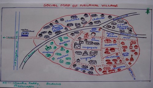
Social mapping is the most popular method in participatory action research. The focus is on the depiction of living conditions and the nature of housing and social infrastructure: roads, drainage system, schools, railway tracks, religious buildings, post office, well, community hall etc. Social mapping is different from other regular maps in significant ways:
- It is made by local people and not by experts.
- It is not drawn to scale. It depicts what the local people believe to be relevant and important for them.
Follow these steps to make your social map:
- Fix the location and time for the exercise in consultation with the local people. Invite them for it.
- Explain the purpose of the exercise to the participants. Ask them to start off with drawing the prominent physical features of their community. Leave it to them to use whatever materials they choose; local as well as other materials as creatively as possible.
- Watch the process alertly. Listen to the discussions carefully. Take notes in as much detail as possible. Avoid chipping in. Your role is limited to facilitation.
- Keep track of who is actively involved, which sections of the society they belong to, and who is being left out. Take proactive steps to involve those left out in the process.
- Once the mapping is over, ask some people to identify their houses in the map.
- At the end, ask questions on the aspects you are not clear about.
- Check the map with others in the community.
Download the worksheet for detailed instructions on how to make a social map.
Worksheet social mapping

